Homepage Markus Weiler
|
|
|
|
|
|
|
|
|
|
|
|
|
|
|
|
|
|

|
|
|
Maybeso experimental catchment, Prince of Wales Island, Alaska |
||||
|
site |
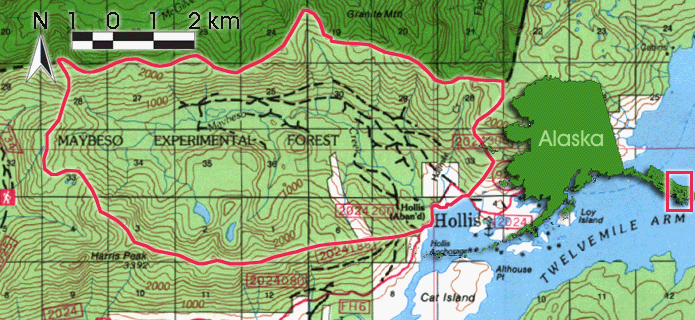
Maybeso Experimental Watershed, a 38.8 km2 watershed, is one of two designated experimental forests within the Tongass National Forest. It is located at the east coast of Prince of Wales Island, at the south-ern end of the Alexander Archipelago in southeast Alaska, in the so called Alaskan Panhandle. The catchment drains into the west shore of the Twelvemile Arm, a deep and narrow fjord extending southwest from the head of Kasaan Bay. The valley is extending on either flank to elevations of 700 masl. up to more than 1000 masl. Harris Peak (1034 masl.) at the southwest side of the catchment is the highest point in the catchment.
|
|||
|
geology |
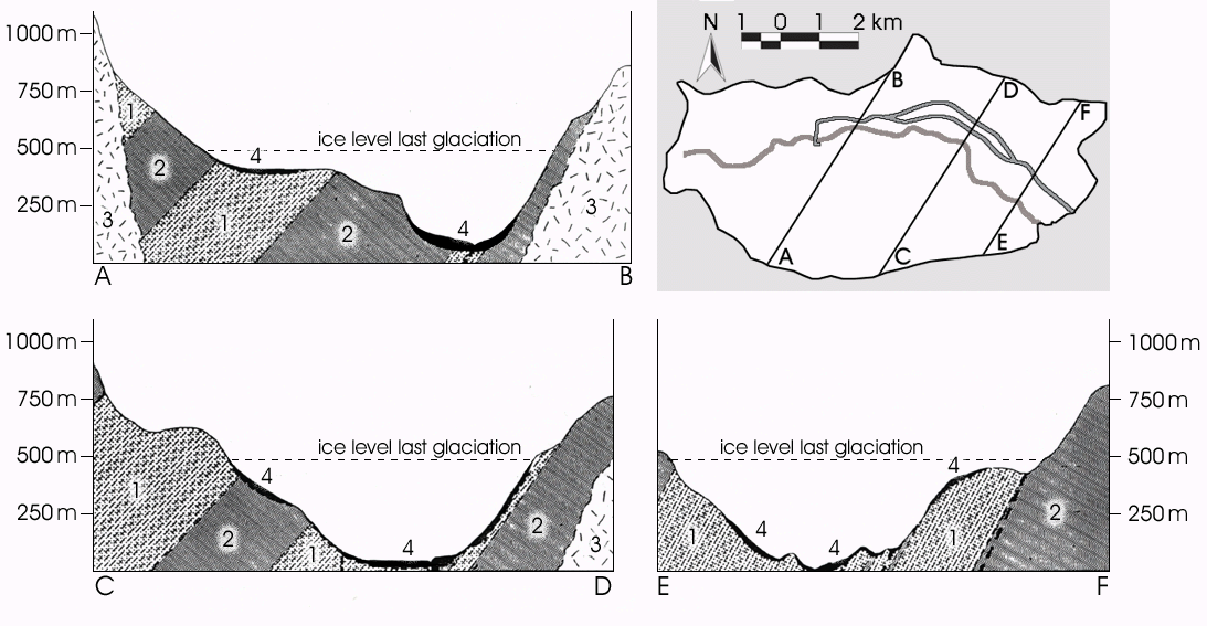
Maybeso Valley's bedrock is composed of a variety of lithologies: The main bedrock types are metasedi-ments, altered locally to varying degrees by regional folding and subsequent intrusions. Beds of black argillite are separated by thick sequences of grey-green greywacke, slate and conglomerate. The broad U-shaped Maybeso Valley is covered by a varying thickness of glacial till, extending on either flank to elevations of about 350 masl. to 450 masl. The area was last glaciated during the Wisconsin glacial advance in the late Pleistocene, when almost all of Southeast Alaska was covered by ice. SWANSTON (1967) pointed out that the main soil types in the Maybeso Valley are Karta soils and Tolstoi soils: The Karta soil is a podzol developed on the glacial till. The Tolstoi soil is a well drained soil developed on steep slopes, covered by colluvium and underlain by fractured bed-rock. Both of them have a relatively thick horizon with undercomposed and decomposed forest litter (U. S. GEOLOGICAL SURVEY 1994). Processes like infiltration, percolation and lateral flow in the litter layer are not only important to litter decomposition but also to runoff generation.
|
|||
|
sub- |
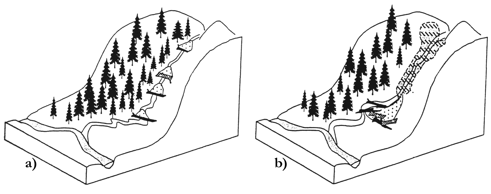
The two chosen subcatchments drain into Maybeso Creek 3 km upstream the estuary. The two subcatchments are designated 'undisturbed channel' UD and 'landslide channel' LS, respectively. Between these channels, there is a third single channel, which is designated 'in-between channel' IB. All the three subcatchments - UD, LS and IB - have been affected by timber harvesting in the fifties.
UD in this case means, that the subcatchment has not been influenced by landslides, debris flows or timber harvesting for more than 30 years. 1961, the last landslide affected the upper part of the UD channel, initialized right below the upper logging road. Single and multiple pieces of woody debris and boulders contribute to the formation of staircase-like channel steps in the UD stream. Woody debris controls local flow direction and channel roughness. The result are small steps and pools, which alter the longitudinal profile of the channel. Referring to this, the IB channel has the same characteristics as the UD channel. The drainage areas are ~20'900 m2 for the UD subcatchment and ~15'900 m2 for the IB subcatchment. |
|||
|
instru- |
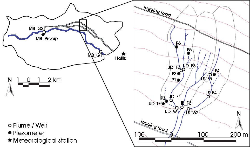
Instrumentation provides meteorolocigal data, streamgaging data and piezometric data from the Maybeso Catchment as a whole and - in a higher density - from subcatchments at the north flank of Maybeso Val-ley. The figure gives an overview over the measurement sites.
Data at all sites have been collected between end May 2002 and end October 2002.
|
|||
|
|