Homepage Markus Weiler

  Home
  Research
  Publication
  Presentations
  Interests
  Links


The Rietholzbach catchment


site


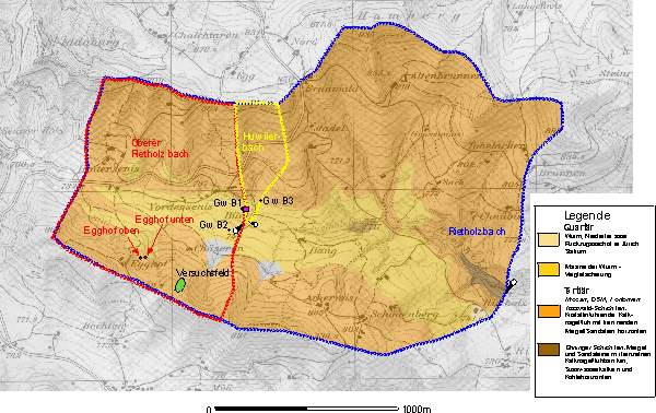
The Rietholzbach Catchment is a small headwater catchment (3.18 km2) in north-east Switzerland (47°23'N, 9°00'E). The land-use of the catchment is 80% agriculture (meadow) and 20% forest. The catchment has been intensively studied since the mid 70s. The Hydrology Section of the Institute for Climate Reasearch at the ETHZ looks after the instrumentation and measurements.
Instrumentation of the catchment (locations see map):
• 3 gauging stations to measure stream runoff of the Rietholzbach Catchment, "Huwilerbach" and Upper Rietholzbach
• Groundwater wells in the riparian zone (GW B1, B2, B3) and a north facing wetland ("Egghof oben" and "Egghof unten")
• A meteorological station and a soil lysimeter (2 m diameter) at the station "Buel"

The Rietholzbach catchments with experimental plot (green) and other measuring devices


geology


The bedrock geology of the catchments mainly consits of sediments of the "Obere Suesswassermolasse" (tertiary). This sediments ("Toesswald Schichten") are conglomerates of calcic and igneous rocks combined with sandy and muddy layers. In the valley moraines from the quartary lay over the sedimentary rocks.
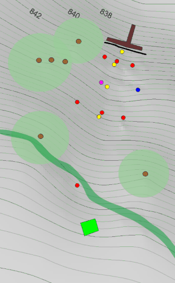
Geology of the Rietholzbach catchment


hillslope
plot

     
Plot Topography

Legend
Tensiometer (Soilmoisture Equipment) and Piezometer
TDR Probes (Moisture Point)
Datalogger (Campbell) and Soil Temperature
Rain Gauge
Pit
Continuous measuring of Overland Flow and Subsurface Flow. The subsurface flow is devided into 3 components:
• Upper left subsurfae flow (0-1.2 m)
• Upper right subsurfae flow (0-1.2 m)
• Deep subsurface flow (1.2-2.5m)

Lateral flow in the soil seems to be an important contribution to runoff. Experiments at the hillslope scale with the larger sprinkling system are planed. Lateral flow velocities, the contribution area and the extent of interconnection between vertical and lateral flow paths will be investigated.
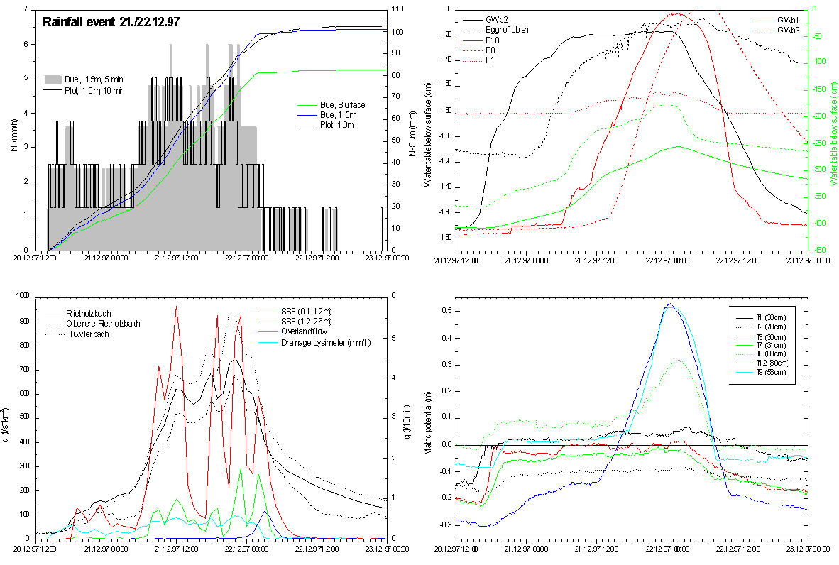
• Measurement of flow components (surface, subsurface) and monitoring of soil water content and potential under different simulated and natural rainfall conditions.
• Using ionic and fluorescent tracer to measure lateral subsurface flow characteristics under steady state conditions by applying rainfall intensities less than the infiltration capacity of the soil to prevent surface runoff. Conventional transport models will be used to quantify the lateral flow processes best by using at least two sampling points at the hillslope.


flood


A heavy rainfall event occured in December, 21st, 1997. The rainfall amount exceeded 100 mm during 1.5 days. The reaction of the experimental plot to the event correlates well with the discharge in the three sub-catchments of the Rietholzbach catchment. The dominating flow component was the upper subsurface flow, however, the deep subsurface flow increased after the plot was partially saturated. The antecedent soil moisture conditions were wet (matrix potential between 0 to -30 cm)

Event 21.12.97 Experimental Plot and Rietholzbach Catchment
Event 21.12.97 Experimental Plot and Rietholzbach Catchment (click on the image for details)